
Samaria Gorge hike map: entrances, stages and exit
Last updated October 2026
Compare the route extent
Original schematics show place order, not measured geography. Neither is a navigation map or proof of current entry permission.
Your selected route view stays in this browser. Choose Both routes to restore the overview.
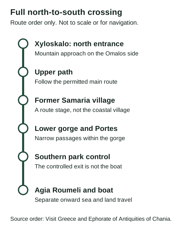
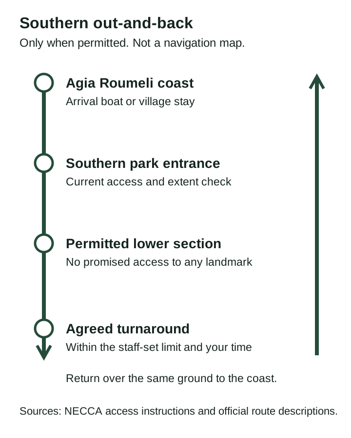
| Order | Place | Role in the full route |
|---|---|---|
| 1 | Xyloskalo | Northern controlled entrance on the mountain side. |
| 2 | Former Samaria village | Interior stage, distinct from the coastal village. |
| 3 | Portes | Lower gorge passages inside the route, not an entrance. |
| 4 | Southern control | Park entry or exit, separate from the boat. |
| 5 | Agia Roumeli | Coastal village and sea departure task beyond the park control. |
Measured track distance and cumulative climbing from these drawings: unknown. The article quotes approximate NECCA distances with their own named endpoints. No elevation profile is supplied.
Place order checked 15 October 2026 against Visit Greece and the Ephorate of Antiquities of Chania. Access: NECCA. Original diagrams by this independent guide; no external basemap or route geometry is used.
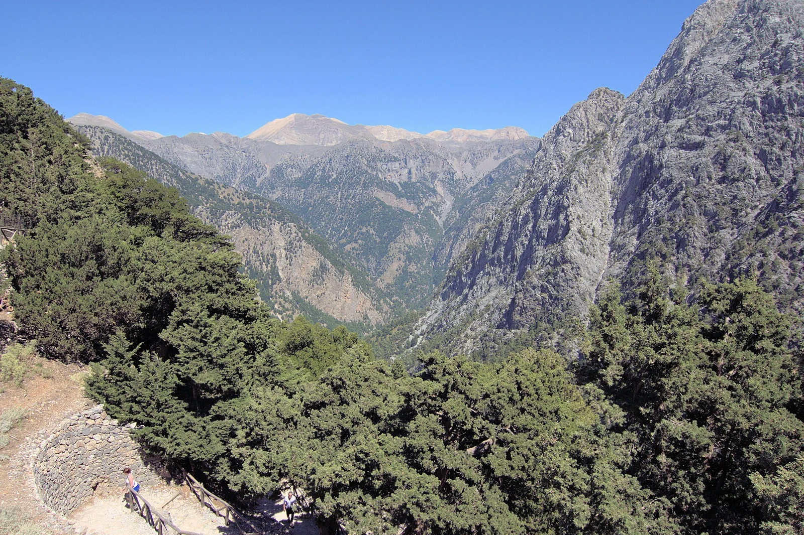
Photo: Zde, CC BY-SA 4.0. Resized and converted to WebP.
,_Crete,_076235.jpg)
Contents10
- Read the Samaria Gorge hike map by endpoints
- The full crossing from Xyloskalo
- The southern out-and-back
- Distances: keep the named endpoints attached
- What the map does not show
- Use the map to check transport
- Read the reference on a phone or on paper
- Map sources and limitations
- Route-map questions
- Verdict on the Samaria Gorge hike map
Use this Samaria Gorge hike map reference to keep the mountain start, the controlled park route and the coastal finish distinct. The diagrams show the order of places, not a measured track. Compare the full crossing with the southern return walk before booking transport. Permission for either route still comes from NECCA.
The full downhill sequence runs from Xyloskalo through the former Samaria village and lower gorge to the southern control, then on to Agia Roumeli. A southern visit starts at the coast and returns there after an allowed partial walk. These original schematics are not to scale or for navigation. They show route extent without promising entry or a particular turnaround.
Read the Samaria Gorge hike map by endpoints
Start with the place where your walk begins and the place where your day must end. A bus to Xyloskalo and a boat from Agia Roumeli belong to opposite ends of the full crossing. A visitor arriving at Agia Roumeli by sea has a different walking task, even if both plans use part of the lower gorge.
The route reference above lets you view both choices or one at a time. Each diagram has its own enlarge link and text description. With scripts turned off, both stay visible. The lines are drawn to make the sequence clear; their length and angle do not measure distance or slope. They do not give compass direction.
For the whole outing, read the hike guide. It brings the walking choice together with access and the return. A map is useful for understanding the shape of a plan, but cannot settle whether its transport or entrance is operating on your date.
The full crossing from Xyloskalo
Xyloskalo is the northern entrance on the mountain side. NECCA describes it as the start of the popular downhill walk. Check that a road transfer names this entrance, rather than only “Omalos”, which can refer to the wider plateau or a place to stay.
The main path descends through the upper wooded section. Former Samaria village is a stage inside the gorge. It is not the coastal village where you will look for your boat. A message saying “meet at the village” needs a clear place name before it can serve as a return plan.
The lower section includes the narrow passages known as Portes or the Iron Gates. After the southern park control, the route to Agia Roumeli remains. The diagram keeps that leg separate so that the gate is not mistaken for the boat departure point.
At the coast, use the actual carrier's boarding instructions. The schematic does not mark a fixed pier, ticket office or meeting point. Those details can change and should come from the provider for the service you intend to use.
The southern out-and-back
A southern visit begins with access to Agia Roumeli, often by boat. You then walk towards the controlled southern entrance, enter only if allowed and return to the same coast. It avoids the full northern descent, but adds a return over the ground you have just walked.
The southern diagram uses “staff limit and chosen turnaround” as the inland endpoint. That is deliberate: a diagram should not promise the Iron Gates when permission or time may restrict the visit. NECCA's general rules allow limited later entry on the south, but a current closure overrides those broad rules.
Work backwards from the boat you need to catch. Include the return from your turnaround, the exit task and the walk to the actual boarding point. Do not set a turnaround from the time spent walking inward alone. Tired feet or a stop can change the pace on the way back.
Distances: keep the named endpoints attached
The NECCA General Description panel gives approximate figures for the route. They are useful when read with their endpoints. They are not measurements taken from our drawings.
| Source description | Approximate distance | Endpoint distinction |
|---|---|---|
| Main path through the gorge | 13 km | The controlled path is separate from the coastal arrival |
| Southern entrance to Agia Roumeli | Another 2 km | This is outside the main-path total |
| Popular full walk | 15 km | Xyloskalo to Agia Roumeli, not door to door |
| Portes from the southern outpost | 1.5 km | This is from the park outpost, not from the boat |
Scroll for more →
The last row is a common source of confusion. Adding a distance from the outpost to a plan that starts at the sea leaves out the approach. An out-and-back also includes the ground covered twice. Keep the start, turnaround and finish beside any total you use.
Do not read cumulative elevation gain from the route line. NECCA identifies Xyloskalo at about 1,227 m and Agia Roumeli at sea level, but a start and finish height are not a full elevation profile. Our schematic provides no contour lines or measured climbing totals.
What the map does not show
This reference has no survey track or live position. It has no turn-by-turn function. It does not show every rest place, water point or crossing. Use the marked route, current signs and park staff on the ground. A route saved to a phone cannot grant access to a closed path.
It also does not show a road through the gorge. NECCA says vehicles cannot access the gorge and only the main path is open to visitors. A road transfer to one end should not be confused with a vehicle meeting you midway through the walk.
The lower riverbed can have bridges or placed stones for crossings. Their current use belongs to the on-site route and staff direction. A neat diagram should not imply that every crossing is a permanent bridge or that conditions stay the same after rain.
Use the map to check transport
Write each booked leg against a named endpoint. An outward road journey should leave you where the intended walk starts. A sea departure should leave from the coast you can actually reach within the day. The onward road journey must then serve your final base or car.
For a full crossing with a car left at Xyloskalo, the car is still on the mountain side after you reach the sea. A boat towards Sougia may form part of a recovery plan only when its onward service is confirmed. A boat towards Sfakia does not put you beside that parked car.
For a southern visit, match both the inward and outward sailings. The existence of an afternoon boat out of Agia Roumeli does not prove there is a suitable morning boat in. Check the route direction, date range and weekday with the carrier.
Use these questions to spot gaps before paying:
- Does the road transfer end at the correct entrance?
- Does the walk include the coast beyond the park control?
- Is the return boat leaving in the direction you need?
- Does the next road leg reach your actual base or the car?
- What happens if a closure or cancelled sailing removes a required leg?
Read the reference on a phone or on paper
Tap either diagram to open its full SVG. The labels stay as text and the shapes can be enlarged without relying on a tiny screenshot. The waypoint list below the drawings repeats the main place order for readers who do not use the image.
Printing the page shows both routes and their captions. A chosen screen filter does not hide the other route from the print view. Keep the source notes with a saved copy, and remember that a printed access observation becomes old. Read the current authority notice again before travel.
For hot-season planning, the August guide explains the day around heat, the early start and the coastal finish. A route picture cannot show how exposed or tiring a section will feel on the day.
Map sources and limitations
Place order is drawn from Visit Greece's route account and the Ephorate of Antiquities' route project, with the approximate endpoint figures checked in NECCA's General Description panel. The diagrams were made for this independent guide. No third-party map tile, GPS track or borrowed route geometry is used.
These sources serve different jobs. The heritage project helps identify sites along the route. NECCA supplies park rules and current notices. A historic route description is not evidence that a particular entrance is open today.
Route-map questions
Is the former village the same as Agia Roumeli?
No. Former Samaria village is inside the gorge, while Agia Roumeli is the coastal village beyond the southern control. Keep the full name in any meeting plan. Confusing the two can make a walking-time estimate or pickup instruction misleading. The diagram marks them as separate stages for that reason.
Does the southern diagram guarantee the Iron Gates?
No. It shows an allowed lower section followed by a turnaround and return. The permitted extent, staff advice and your own time limit decide how far you go. A current closure may prevent entry altogether. A named landmark in a tourism account does not promise you can reach it on your date.
Verdict on the Samaria Gorge hike map
Use the Samaria Gorge hike map reference to check place order and keep the two walking plans distinct. Keep distances tied to named endpoints and leave navigation to the marked, permitted route. Once the walking extent is clear, verify the boat and road legs that complete the day.