
Samaria Gorge geology: how the landscape formed
Understand Samaria Gorge geology through its rock layers, folds, uplift and water, with plain explanations and named scientific sources.
Last updated October 2026
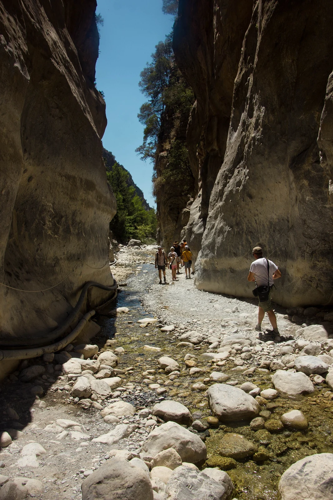
Photo: Ιωάννα Κουργιαντάκη, CC BY-SA 4.0. Resized and converted to WebP.

Contents9
Samaria Gorge geology is the story of rocks formed long before the valley took its present form. Rock layers were squeezed and lifted. Water then cut through them. The pale walls are therefore evidence of several processes, rather than one river carving an untouched block of stone.
The broad picture is rock, uplift and erosion acting over different spans of time. Much of the gorge cuts the Plattenkalk rocks of the White Mountains. Their layers and folds matter, as does water moving both above and below ground. A view from the path can show a feature. It cannot, on its own, tell you that feature's age or cause.
Samaria Gorge geology at a glance
Geologists use the name Plattenkalk for a set of rocks found in Crete and other parts of Greece. In Samaria, these rocks include carbonate layers with chert. Carbonate rocks include limestone and dolomite. Chert is a hard rock with a high silica content. These names refer to the material, not to the form of the gorge.
The study by Manoutsoglou and colleagues, published in Applied Sciences in 2022, reviews the area's geological models. It distinguishes the Plattenkalk series, the Trypali unit and the Gigilos formation. The units have different rock types and structures. The gorge cannot be explained by calling all its rocks identical limestone.
This guide explains the broad processes behind what you may see. It is not a field map for naming every outcrop. Rock identification can need a close study that a hiker should not attempt from an unsafe spot. Stay on the permitted path and leave samples in place.
Rock layers beneath the White Mountains
Some rocks begin as material laid down in water. Burial and later forces alter that material over time. Geologists call the sequence of layers a stratigraphy. Working out that sequence helps them ask which rocks came first and how later movement affected them.
“Metamorphic” means that heat or pressure has altered a rock. It does not mean the rock melted into lava. The term matters here because the research concerns rocks changed during the building of the mountains. Marble is one familiar example of an altered carbonate rock.
Do not confuse a rock's original age with the age of the gorge. Sediment may form in one period, turn into rock later and move again before a valley cuts through it. A date assigned to a layer is not a date for the path beside it.
The 2001 geological mapping study used field mapping and structural work to examine the Samaria area. Its authors compared possible models of the rocks below the ground. That is a useful reminder that a map contains an interpretation of evidence, as well as visible surface features.
Folding, fractures and uplift
Rock does not always stay flat after it forms. Under pressure, layers can bend into folds. They can also break along fractures or move along faults. These processes act at different scales. A bend in a small layer and a fold across a mountain are not the same sized event.
The 2003 structural study by Manutsoglu, Soujon and Jacobshagen reports a large fold around the gorge. It also examines small rock structures and mineral fabrics. Its findings come from field and close-scale evidence, not just the outline of the valley.
Uplift means land rising relative to a reference level. Erosion removes material from that land. The processes can happen together: rising land can still lose rock as water cuts into it. A high valley wall can therefore record both the mountain's movement and the cutting of the gorge.
Avoid the claim that one earthquake “made Samaria” unless a source states exactly what it means. A fault can guide erosion without every part of the valley forming at once. Likewise, a crack visible today does not tell a visitor the date of its first movement.
A simple way to read the sequence
Think of the story as several questions rather than one exact birthday:
- Material: What rock is present here?
- Structure: How have its layers bent or broken?
- Relief: How did the land gain height?
- Erosion: What removed rock to make this valley?
- Present conditions: What is water or loose rock doing now?
Each question needs its own evidence. One photograph cannot settle all of them. A geological model may answer some well and leave others open.
Water above and below the path
Water can carry sediment along a channel. Over time, it wears and removes material. In carbonate rock it can also travel through joints and openings below the ground. The term karst describes terrain where dissolution of soluble rock helps create features such as caves and underground drainage.
These processes explain why a visible stream is only part of the water system. A dry surface at one spot need not mean there is no water below it. Nor does a flowing stream prove that water is safe to drink. Geology and drinking-water advice answer different questions.
In their EGU presentation on Samaria springs, Manoutsoglou and colleagues describe a stream that passes below ground and reappears farther down. They distinguish wet-season catchment flow from the contribution of springs in the dry season. Their work studies how the rocks and springs relate.
For a visitor, the useful lesson is to avoid reading a whole watershed from a brief view. A quiet channel in dry weather is a moment in a larger system. It is not proof of conditions after rain, and it does not justify entering when the park has closed.
Features visible from an allowed walk
Layering is one feature to look for where the path gives a clear view. Some surfaces show bands or beds at different angles. Describe what you can see without guessing the full structure behind the cliff. A pale stripe need not be a separate type of rock simply because it stands out.
Folds can make layers look curved. A broken face may expose them at another angle. The apparent pattern also depends on where you stand. This is why geologists measure orientations and compare many outcrops rather than naming a fold from a single snapshot.
Loose stones at a cliff's foot show that the rock face and valley floor are linked. Rock can fall or move downslope as it breaks apart. Such material is not a cue to walk closer to the wall. Follow the posted instructions and do not stop in a place that staff identify as exposed.
The narrow passages in the southern gorge are another kind of feature. They help show how the valley's width varies. Their dramatic appearance does not prove a particular formation date. A useful description separates the form you can observe from the process a study uses to explain it.
| Visible feature | A useful observation | What it does not prove |
|---|---|---|
| Rock bands | Layers are exposed at this face | Their age without mapped evidence |
| Curved layers | The beds are not all flat | The full size or date of a fold |
| Fractures | Openings cross the rock | A recent earthquake at that spot |
| Loose stones | Material has moved from nearby slopes | That a wall is stable today |
| Water in a channel | Surface flow exists at the time seen | Drinking quality or conditions upstream |
Scroll for more →
Why the scientific models have limits
A geological section is a reasoned view through the ground. Much of the rock beneath a mountain cannot be seen. Researchers use the surface, measurements and other evidence to infer that structure. A model can be useful without claiming every unseen detail is certain.
The Samaria literature includes different ways to explain the order and contact of rock units. The mapping paper and later review discuss those choices. This guide does not choose a winning model from a visitor photograph or compress the debate into a single unsupported timeline.
The Greek UNESCO submission supplies broad geological context for the White Mountains. Its purpose is a heritage proposal. For a specific technical claim about a rock contact or a deformation event, a named geological study is the stronger source.
Scale is another limit. A statement about the whole White Mountains is not automatically true of every wall in Samaria. A study of a spring is not a survey of every drinking point. Keep the area studied attached to the finding.
Facts and source links checked: 15 October 2026. No rock age, uplift rate or wall height is inferred here from an image. Current access is a separate check with NECCA's ticket portal, which reported both entrances closed at the time of that check.
From the rocks to the human story
The former village and churches add another kind of evidence to the landscape. Read the history of Samaria Gorge for the named sites and the limits of their dates. A rock unit and a building do not share the same historical clock.
Choose the visit that fits
A long walk and a southern partial visit require different travel plans. If you want road logistics handled, compare the guide's role and the complete return.
Questions about the rocks
Is Samaria Gorge made only of limestone?
No. Published research distinguishes several units in the wider gorge area. Carbonate rocks are important, but the studies also describe other rock types and differences between units. Use the technical sources for a named outcrop. The colour of a wall is not enough to identify its full composition.
Did the river make the whole gorge?
Water-driven erosion is part of the explanation, alongside the rocks and their structure. Earth movement helped create the mountain setting in which that erosion acted. Treating the valley as a river cutting an unchanged flat surface leaves out much of the history that the geological studies examine.
Does a dry stream bed mean there is no water?
No. Research on Samaria's springs describes water moving below the surface and appearing again farther down. That does not mean any visible water is fit to drink. Use current park advice for drinking points, and carry what you need rather than relying on a geological description of springs.
Can I collect a rock sample?
The former park body's visitor rules prohibit damage to geological formations. Leave rocks and fragments in place, and follow current staff instructions. A photograph from the permitted path can record a visible feature without removing it. Do not step into a closed area to get a closer view.
Verdict on Samaria Gorge geology
Samaria Gorge geology makes more sense when rock age, earth movement and valley erosion stay separate. Look at the layers and water with those questions in mind. For the broader visit, return to the Samaria Gorge National Park guide. Let the science explain the setting, while current park instructions govern the walk.